

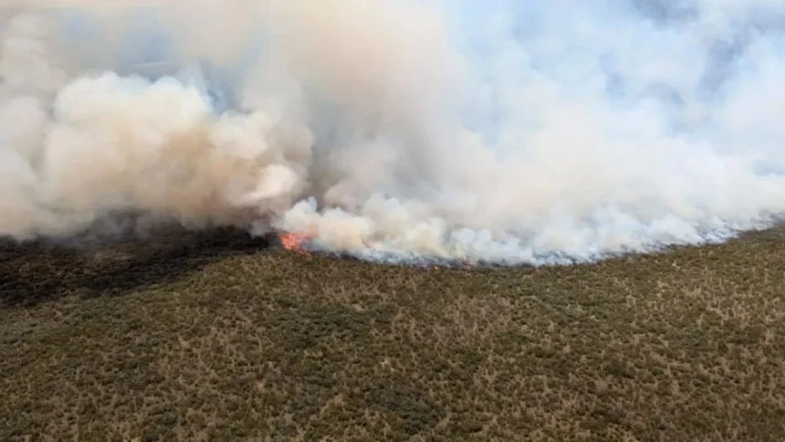
A fierce wildfire that broke out on September 1, 2026, near the Rutundu Lodge area in Mount Kenya National Park has destroyed vast swathes of high-altitude vegetation, exposing critical gaps in Kenya’s emergency responses for remote ecological zones.
Standard Newspaper
Visiting the region on Tuesday, September 8, Environment, Climate Change, and Forestry Cabinet Secretary Dr. Deborah Barasa confirmed that the fire—the largest of five outbreaks recorded in the Mount Kenya ecosystem since mid-August—has consumed over 3,000 hectares. Independent conservation monitoring by the Rhino Ark Charitable Trust suggests the burnt moorland area could be as high as 8,700 hectares.
The Star
+ 1
FIREFIGHTING OPERATION FLOW
[ September 1: Blaze ignites near Rutundu Lodge ] ──► Spreads across dry moorlands
│
▼
[ Rapid Multi-Agency Deployment ] ──► 400+ Responders (KDF, KFS, KWS)
Aerial support via Tropic Air
│
▼
[ Current Containment Status ] ──► 85% Suppressed / Mop-up active
1. Why the Flames Spread So Rapidly
The moorland terrain of Mount Kenya was rendered highly flammable due to a combination of seasonal weather conditions and dense vegetation:
The Star
Seasonal Drought & Winds: High September temperatures combined with strong mountain winds accelerated the spread across two distinct fronts—one moving north toward Marania Forest and another moving southwest toward Chogoria.
The Star
Combustible Invasive Flora: CS Barasa noted that the fire’s intensity was fueled by dense vegetation that grew during the previous rainy season, alongside invasive species like Erica, which act as natural tinder in dry conditions.
The Star
+———————————–+———————————————————————————+
| Crisis Parameter | Official / Conservation Assessment |
+———————————–+———————————————————————————+
| **Ignition Date & Origin** | September 1, 2026 — Rutundu Lodge area (Moorland Zone) |
+———————————–+———————————————————————————+
| **Estimated Area Damaged** | Govt: >3,000 Hectares | Rhino Ark Assessment: ~8,700 Hectares |
+———————————–+———————————————————————————+
| **Current Containment Rate** | 85% suppressed (Focus shifted to hotspot mopping) |
+———————————–+———————————————————————————+
| **Deployed Personnel** | 400+ (144 KDF Officers, 100 KFS Personnel, KWS, Mount Kenya Trust, Locals) |
+———————————–+———————————————————————————+
2. Multi-Agency Mobilization and Wildlife Impact
Over 400 responders have been deployed to combat the blaze. Officers from the Kenya Defence Forces (KDF) and Kenya Forest Service (KFS) have worked alongside teams from the Kenya Wildlife Service (KWS), Mount Kenya Trust, Lewa Wildlife Conservancy, and Rhino Ark, supported by Tropic Air for daily aerial reconnaissance.
The Star
+ 1
> “There are no human casualties, and large wild animals have moved away safely from the affected zones. However, smaller ground species like rabbits and rodents have been impacted.”
> — Dr. Deborah Barasa, Cabinet Secretary for Environment, Climate Change & Forestry
3. Structural Gaps and Long-Term Mitigation
The disaster has highlighted significant operational constraints in managing fires in high-altitude, hard-to-reach terrain. In response, the Ministry has outlined several long-term policy and infrastructure priorities:
The Star
Dedicated Mountain Infrastructure: Expanding access roads into remote forest zones and constructing a high-altitude airstrip to facilitate the rapid deployment of firefighting personnel and heavy equipment.
The Star
Aerial Seeding & Ecosystem Recovery: Launching post-fire restoration initiatives—including aerial reseeding programs—set to begin ahead of upcoming Mazingira Day environmental exercises.
The Star
Ring-Fenced Conservation Funding: Advocating for dedicated statutory budget lines within the Ministry to enhance early-warning systems in coordination with the Kenya Meteorological Department.