
The intensification of the rains isn’t an isolated event. Meteorologists point to a combination of the Inter-Tropical Convergence Zone (ITCZ) and unique moisture-laden winds from the Indian Ocean. This “perfect storm” is expected to peak between May 10 and May 13, creating a period of sustained saturation.
When the ground is already wet from previous weeks of rain, its ability to absorb more water vanishes. This leads to “Runoff,” where water simply sits on the surface or rushes toward the lowest point. In Nairobi, that “lowest point” often means the roads, your living room, or the heavily populated informal settlements along the riverbanks.
Mapping the Danger: Nairobi’s Red Zones
If you are a resident of the capital, “Nairobi” is a broad term. However, certain areas are historically more vulnerable to the specific mechanics of urban flooding.
1. The Riparian Standoff
Nairobi Governor Johnson Sakaja has spent the better part of the last month leading a controversial campaign of riparian demolitions. The goal? To clear the natural paths of the Nairobi River and its tributaries. Areas like Mathare, Mukuru, and Kibera remain high-risk zones. Despite the clearing of structures, the sheer volume of water expected could still cause these rivers to burst their banks, affecting anyone living within 30 meters of the water.
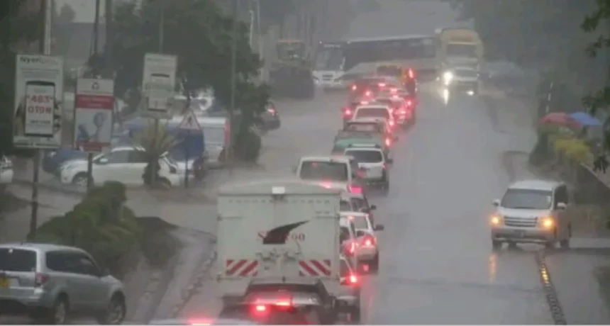
2. The CBD and Transport Hubs
Expect major disruptions at the Nairobi Central Business District (CBD), particularly around Ojijo Road, Museum Hill, and the Expressway exits. The drainage systems in these areas, while improved, often become clogged with solid waste during the initial rush of heavy rain, leading to deep pools that can stall a car in seconds.
3. The Lower Estates
Estates such as South C, Eastleigh (Section 3), and parts of Syokimau should prepare for “back-flow” flooding. In these areas, the water doesn’t just come from the sky; it comes up through the drains when the main sewer lines become overwhelmed.
Safety First: A Survival Guide for the Week
A flood isn’t just a weather event; it’s a series of split-second decisions. Here is how to navigate the next seven days:
The “Turn Around, Don’t Drown” Rule
It sounds like a cliché until you’re staring at a 10-meter stretch of water on the road. Do not drive through it.
The 6-Inch Rule: Just six inches of fast-moving water can knock an adult off their feet.
The 12-Inch Rule: A foot of water is enough to float most small cars. Once your tires lose contact with the road, you are no longer a driver; you are a passenger in a boat with no oars.
Lightning and Thunder
The upcoming intensification is expected to be accompanied by severe thunderstorms.
Indoor Safety: Avoid using corded phones or being near grilled windows during a storm.
Outdoor Safety: If caught in the open, do not seek shelter under a tree. A lone tree is a lightning magnet. Seek a low-lying area or stay inside your car (the rubber tires and metal frame provide a “Faraday Cage” effect).
The Downstream Effect: Why Tana River Should Care
One of the most critical warnings from the KMD is about the “Downstream Warning.” You don’t need it to rain in your backyard to experience a flood.
As heavy rain falls in the Aberdare Ranges and Mt. Kenya, that water travels down through the Tana and Athi rivers. Residents in the Tana River County and Garissa may see their river levels rise suddenly under clear skies. This “silent flood” is often the most dangerous because it catches people off guard.
The Economic Impact: More Than Just Wet Shoes
For a digital entrepreneur or a business owner in Nairobi, the floods present a logistical nightmare.
Supply Chain Disruptions: Expect delays in the delivery of fresh produce and goods from the “food basket” regions of Nyandarua and Nakuru.
Power Outages: Kenya Power (KPLC) often experiences outages during heavy storms due to falling trees and lightning strikes on transformers. Ensure your power banks are charged tonight.
Insurance: Now is the time to check if your car or home insurance covers “Acts of God” or hydro-static lock. Most standard motor policies in Kenya do, but only if you didn’t “intentionally” drive into the water.
Emergency Contacts to Save Tonight
Keep these numbers in your phone before the power goes out or the signal gets spotty:
Nairobi County Emergency: 020 2222181 / 0725 624 489
Kenya Red Cross: 1199 (Toll-Free)
KPLC (Power Outages): 97771
Final Verdict: Preparation Over Panic
The Kenya Met Department isn’t issuing this warning to cause panic, but to trigger preparation. The intensification of the rains from tonight is a reminder of our city’s vulnerability and our need for resilience.
Whether it’s moving your expensive electronics to a higher shelf, checking your wiper blades, or simply deciding to leave work an hour early to beat the “flash flood traffic,” your actions in the next 24 hours will define your week.